

 14:17
14:17
 Information technologies

Eric Calais - CNRS - Geosciences Azur, Sophia Antipolis
The satellite positioning system GPS is a technology that is revolutionizing many areas of industrial and scientific. The system is reliable, accurate, available anywhere and anytime, easy to use. Moreover, its growing success is associated with a steady decline in hardware prices. The time is perfect for s'interéresser GPS, progress and new opportunities opened up by this technology.
"Ladies and gentlemen, we begin our descent, please take your seats and fasten your belt." This is a phrase often heard a few minutes before the landing of an airliner. Soon after, the aircraft is in final approach and descends steadily to its destination, perfectly aligned with the direction of the track. A few minutes more and the aircraft is close enough to the ground. It rears up slightly just before touching and aterrit. Nothing special for the passengers, happy to arrive safely. However, this final approach and the landing has been made fully automatically without the intervention of the pilots, with a guidance system which are enslaved control of the plane ... And what amazing guidance system: it is Indeed, a satellite technology, the Global Positioning System, or GPS. No, this is not science fiction. This device is actually in place in the United States and complements the traditional navigation signals emitted from the ground that were until now the only way to land in conditions of minimum visibility. In France, Airbus Industries, in collaboration with Aerospatiale, Sextant Avionics and Technical Service of Air Navigation, is testing the system since October 1994. He has already proven its efficiency and high reliability, providing positioning of the aircraft with a vertical accuracy better than 1 meter.
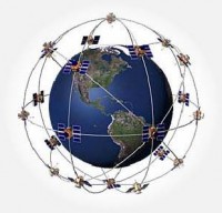
Positioning available anytime, anywhere GPS is a satellite positioning system to determine its position, speed and direction of travel at any time and any place (see Box 1). A technological dream only 10 years ago, a reality since 1993, when the first receivers were sold to individuals. GPS has quickly been very popular with sailors, boaters as professionals. Ease of use, accuracy and reliability outperform a largely traditional navigation systems such as Deccan, Loran, Satnav, etc.. A wide range of material is currently available, suited to most needs of navigation and positioning. It provides a precision that ranges from a hundred meters to several millimeters depending on the type of receiver and the technique used (see Box 2).
A performance / cost adaptable to all needs. As for prices, there are portable receivers the size of a calculator for less than 3000 francs. Those used for shipping, if they have the "differential", worth about 10,000 francs. At the other end of the spectrum, there are geodetic quality receivers, capable of providing a location within a millimeter, for 150,000 francs. A bit expensive, it is true, but these receptors were worth twice as there are only four years. Each application, according to his needs in terms of precision, speed to result (real-time positioning or delayed), and of course the budget, will find its natural place in the range offered by the GPS.
Positioning System military hijacked by the civilian economy GPS is a U.S. military at that. However, it is accessible to any civilian who equips a suitable receiver. Technology leaders of GPS receivers are of course American. Some foreign companies, however, as the French company Sercel, have embarked on the construction of receivers and the development of integrated solutions to meet specific applications. Of course, the U.S. military reserve access to the full capabilities of GPS, and the right to degrade all or part of the system. For example in case of military conflict that would involve. Currently, however, only some of the capabilities of GPS is available to civilian users, constrain the absolute positioning accuracy in real time about 100 meters (while the U.S. military have a precision of less than 10 meters) . However, civilian applications of GPS have become so large and represent a major economic as the pressure is high so that the system is at least maintained in its current state of performance, even for the maximum precision is made available to civil users. In addition, a system very similar to the GPS was set up by Russia, GLONASS, which starts to be operational. The issue of preventing access to the GPS to hostile nations because of his losing interest if there is a competing system. Recognizing the importance of these new developments, the U.S. Vice President Al Gore said on March 29 that his government had decided "to help the fledgling industry of GPS to achieve a turnover of $ 8 billion before the end of this century. " This rapid expansion (the current turnover of GPS industry in the United States is about $ 2 billion) would be accompanied by about 100 000 new jobs, so we understand the economic potential of GPS.
Some applications to the positioning of vehicles One of the first practical applications of GPS beyond the simple positioning was implemented on the airport in Chicago, one of the busiest in the U.S.. It was not to allow pilots to position themselves in flight, as one might think, but to allow the control tower at any time to know the position of aircraft on the ground in order to better manage their travel, sequencing of takeoffs and avoid collisions, especially on foggy days. Each plane is equipped with a GPS receiver calculates its position and continuously broadcast by radio to the tower control unit. In turn, a computer receives these positions and displays in real time on screen, on a base map showing the map of the airport. A "no radar radar", in short, that allows controllers to have all the necessary information summarized on a single screen.
This idea has since been transferred and adapted to many situations where it is necessary to continuously monitor the position of vehicles from a control station which is to better manage their travel. An example that has made the press recently is that of taxis in the city of Nice. Each one is equipped with a GPS, which transmits its position to a control center. Increased efficiency, but also security. Last March, a thug had the bad idea to steal a taxi ... equipped with a GPS. Had he known, he would have understood the limited chances he had to escape the police, informed continuously and in real time of the journey!
Similarly, monitoring of large public works projects or careers can be greatly facilitated by equipping vehicles with GPS, the position is transmitted in real time to the computer of the foreman. The latter can always see the state of activity of its construction, the availability of equipment, etc.. It can react quickly if necessary as it has all of the information under the eyes, updated continuously, from his office. Now let's talk strategy and precision measurements. This type of application typically requires an accuracy of one meter. The receivers can be used to type single frequency, but will have to measure the signal phase (see Box 2). The best strategy for the lowest cost, is to equip the site with a GPS reference station that emits differential corrections to the receptors on mobile machinery. These calculate their position continuously and transmitted by radio to the control center.
Finally, coupled with GPS maps and digital traffic can already guiding vehicles. This technology is great development in Japan (see article in the April 1995 International Technologies) and begins to appear in France.
GPS, digital mapping and GIS For surveyors and surveyors, whose work is mainly the production of maps, GPS is becoming an indispensable tool. Conventional methods of positioning under the theodolite are certainly as accurate as GPS, but it offers a performance always sufficient for comfort and speed from. Measured points, for example, need not be intervisible. By placing a fixed receiver in the middle of a field map, one person, equipped with a second receiver can set dozens of points in one day. An accurate map of flood zones in a flood plain, the resumption of a municipal cadastre, delimitation of land become achievable tasks quickly, accurately, and with a reduced workforce. Software for data processing are sufficiently user-friendly and easy to use to enable the surveyor to deal in an hour or two the data collected in a full day of field measurements. A reliable and accurate results can be delivered to the customer the same day.
In addition, the result of a campaign of GPS mapping is digital, then integrated directly into a computer by software such as "GIS", or GIS. By entering into a GIS map data for a region (topography, layout of roads, cadastral boundaries, distribution of vegetation cover, etc..), One can leisurely road design overlay to the map of flood zones and evaluate the impact of a flood, an overlay map of the settlements with the risk of forest fires, etc.. In addition, the map data base is more often the satellite image, GPS has another advantage here. It allows easily the "georeference", that is to say the place a rigorous system in a mapping. Simply position on the ground, GPS, although some sites identified in the satellite image.
Towards an integrated technology in everyday life GPS technology has come to prove its reliability and accuracy. The current challenge is no longer "how to" but "what to do." The place is the imagination and the implementation of new applications of GPS to the needs and problems. For which, moreover, a precise positioning is not necessarily essential. Indeed it appears that the GPS market is driven by falling prices of hardware as an application in terms of accuracy only. The GPS is actually becoming a regular accessory of everyday life, just like a wristwatch. Proof is the concept of "Wide Area Differential GPS", which is beginning to emerge in the United States: a network of 450 reference stations will soon make differential corrections on the FM band, which will cover 90% of North America. Meter precision for an annual subscription of $ 600, which could be better?
 Posted in: technology


2 commentaires:
Nice post.Thank you,I found the best resource to update my knowledge.Hope this information can help me to crack GIS jobs in Hyderabad.
Nice post.Thank you,I found the best resource to update my knowledge.Hope this information can help me to crack GIS jobs in Hyderabad.
Enregistrer un commentaire